Exwick History Society
When was this picture taken ?
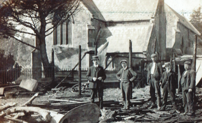
We were recently given an old photograph of a fire where today's Parish Hall stands. Written on it were the words: 'Fire at Exwick Aug 26 ----" (the year being indecipherable).
Exwick Blaze. This Morning. Stores Destroyed. The Church Threatened.' and explained the property involved was a range of wood and corrugated iron buildings. This pre-dates the first Parish Hall or Parish Institute building. That was begun after the First World War using the surplus money from a local fund collected to build the village War Memorial (which was dedicated on 26th June 1920). The money left over began to be used, even before the War Memorial was completed, to organise a campaign and start a scheme to build a wood-lined corrugated iron building for club members and public use, on land leased or rented from the Buller Estates at 5s a year payable at Michaelmas.
Questions & Answers 6-10
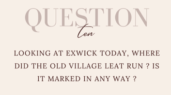
A number of people asked about this at our poster exhibition in June. The Old Village Leat of Exwick seems to have captured the imagination of local people, but where was it, exactly ?
If you visit the online website of the National Library of Scotland you can look at a sequence of overlays beginning with a late Victorian map of Exwick Village, and progressing through overlays of different transparency to today's aerial photo image. We are exploring whether we can show this sequence on our websitem meanwhile look at the late Victorian map extract below, as a guide.
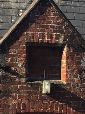
What was written on Exwick's toll notices in late Victorian times; and was this information placed in the recess above the door of the Toll Cottage on Station Road ?
There is a distinct recess in the brickwork above the door to Toll Cottage on Station Road which was perhaps designed as a recess for a notice-board explaining the toll charges ?
Examples of such boards/notices survive on toll houses, but if one was displayed here, above the door, it has long since gone. Is there any hope of finding an image of any such toll charges board ?
Alternatively, might there be a newspaper report, or some other type of record, describing the full range of toll charges at Exwick ? Or a toll ticket listing the categories and charges ?
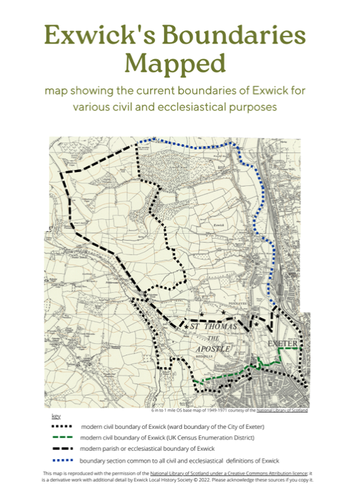
Modern-era Boundaries of Exwick for Civil Administration
(e.g. electoral ward boundaries for Exwick, as part of The City of Exeter)
For the purpose of civil administration, various boundaries have been created for 'Exwick' from time to time. In 1841 the census enumerators for St Thomas Parish chose to refer to all that land north of Okehampton Road as 'Exwick'. Likewise, the City of Exeter introduced its own civil concept of 'Exwick', and modified this severaltimes, to help administer parts of the ancient Manors of Exwick and Cowick as they were absorbed into the city limits.
The city's most recent boundary for 'Exwick' can be seen on the Electoral Division map published by Exeter City Council, which is also enlarged here. This is slightly different from the, presumably earlier version, currently shown on Open Street Map.
Mapping the Boundaries of Exwick
Today there are various Ecclesiastical and Civil Boundaries for 'Exwick'; all of them slightly different (as shown on this map).
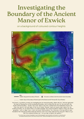
Do you have any thoughts on where the ancient manorial boundaries of Exwick might have been ?
These not known with any certainty, but it seems reasonably likely that on three of the ancient manor's four sides (north, west and east) they would have followed (or not have differed greatly from) today's ecclesiastical or parish boundary.
It is more difficult to imagine or propose where the southern boundary to the 'Ancient Manor of Exwick' may have been. Perhaps it followed the Okehampton Road, as does a part of one of today's civil boundaries, and then continued up Redhills ? This was the way 'Exwick' was defined for the 1840 census, but by then the Prebend of Hayes, which had once occupied part of this area, had long gone.
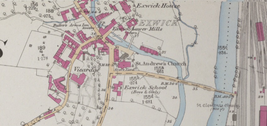
Extract of late Victorian map, reproduced with the permission of the National Library of Scotland, for non-commercial re-use by licence CC-BY (NLS)
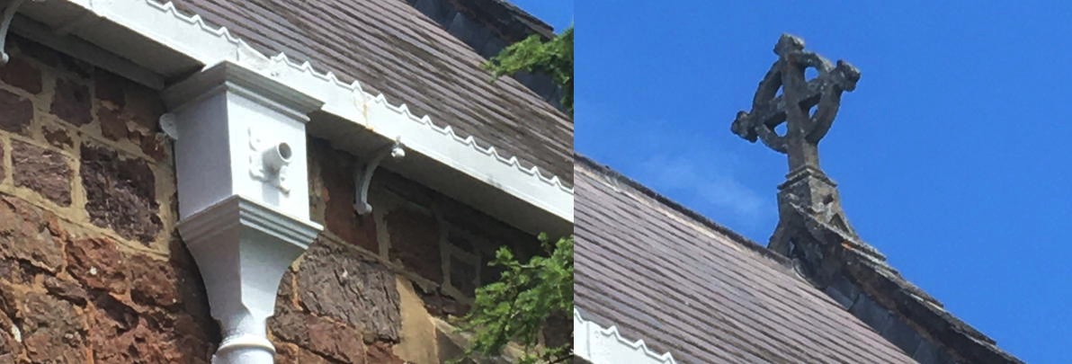
Is there an image of the foundation stone of St. Andrew's Church in its original position ?
This question was asked a few days after our history exhibition of 4th June 2022, (held as part of the Parish Hall's events for the Queen's Platinum Jubilee).
The question was asked because the present-day inscription stone is very low-down, at soil-level on the 1870's church extension. Might the stone, in its original position on the 1840's church wall, have been higher up ?
There is a story that in its original position, there was a space behind the stone where a few contemporary items were sealed-in (a sort of 'time capsule'). Is this fact or fiction ?
Be that as it may, we are helped by a knowledge of some of the parish boundaries in the early C19th. Exwick was incorporated into St Thomas Parish at that time with which it shared north, west and east boundaries. These are shown on the St Thomas Tithe Map of 1839, and it seems reasonable to suppose these would be more or less conterminous with the manorial boundary. In the main, such parish boundaries follow landscape features (a practicable way of forming land boundaries in days gone by) and it seems that the ancient Manor of Exwick was bounded by the following landscape features in the north, west and east:
* the River Exe (or its former course) forms the manor's eastern boundary;
* the Rowhorne Road ridgeline forms much of the manor's western boundary;
* the ridge-line of the hills above Exwick Wood forms the manor's northern boundary (the 'doddan hrycg' of Saxon charters; 'hrycg' being Old English for 'ridge').
The likely southern boundary of Exwick Manor (where it abutted Cowick Manor and/or Hayes Prebend) is more problematic. Exwick was not administered as a separate parish until about 1870 (having been jointly managed with Cowick for centuries) and its southern boundary was little used. For practical purposes, a boundary definition for Exwick parish was created in 1872. At first, this omitted much of the Cleve Estate, though this was later added-in to give a revised ecclesiastical boundary which was close to that which we have today. Whilst this Exwick parish boundary is suitable for modern-day ecclesiastical administration, there remains an academic or historical question as to where the manorial boundaries would have been many centuries ago.
As we see, establishing early manorial boundaries can be problematic and further historical studies would be worthwhile. Clearly there are puzzles left to be solved !
'Beating the Bounds' - we are not aware of such events at Exwick, but we can offer some thoughts on the question of Exwick's boundaries - and perhaps you can add to, or improve on this ?
The Ancient Boundaries of the Manor of Exwick
The ownership of Exwick Manor in late Saxon times was recorded in the Domesday Book which also provides brief details about the manor in early Norman times. However, the Domesday Book does not indicate where the manor's boundaries lay (if indeed there was a charter or custom which set these out by reference to landmarks). Nor are we aware of a description of the manorial boundaries in the later medieval period; nor from the first centuries of the early modern period (e.g. Tudor/Elizabethan and Stuart times).
It is possible that a description of the ancient manor boundaries might turn-up amongst medieval sources, or that an approximation might be attempted from a diligent examination of later records (perhaps from the Bedford Estate, Courtenay, or Buller of Downes archives). However, at present, Exwick's ancient manorial boundaries are largely a matter of conjecture.
photo: Exwick Local History Society archive
photo: Exwick Local History Society 2022
Photos by Exwick Local History Society 2022